Indirizzo
Via Monte, 72100 Brindisi BR
GPS
40.6387393, 17.948407
Le tracce di antichi luoghi nei toponimi della città
Via Monte e Chiesa di S. Maria del Monte, XIII sec., Apostolato del Mare a protezione della gente di mare.
 English Version
Monte anticamente era chiamata la collina che va dalla chiesa dell’Annunziata e via Giudea sino alla Mena, oggi Corso Garibaldi, collina che degradava verso mare, il porto, laddove oggi insiste l’Autorità Portuale. La toponomastica ne mantiene la memoria con la breve via Monte, accentuata dalla presenza della piccola chiesa di S. Maria del Monte, punto di riferimento per l’Apostolato del Mare.
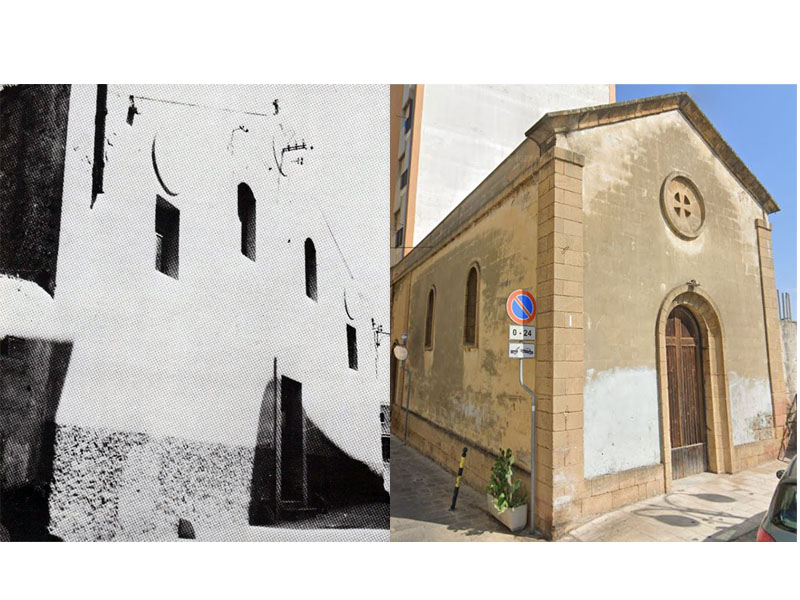
Della chiesa di S. Maria del Monte si ha notizia, ci dice il Vacca, sin dal 1224 dal Codice Diplomatico di Annibale De Leo. Doveva essere, al dire del Moricino, magnifica, tuttavia nel 1674, per le rovine non di meno patite nella Città si è ridotta in picciola forma, commoda però per celebrarsi il Santo sacrificio della Messa, e posta detta chiesa quasi in un promontorio del destro colle della città sù ‘l mare all’incontro della bocca delle due corna al levante. Tuttavia nel corso soprattutto del XX sec., la chiesa è stata ridotta ulteriormente, sia per esigenze del Piano Regolatore post bellico, sia per i danneggiamenti causati dai bombardamenti, originando dal 1950 una struttura radicalmente differente dall’originale (fig.1).
Sul Monte era il Belvedere, anche questo mantenuto nella toponomastica grazie alla via Belvedere, naturale continuazione di via Mattonelle. In località Belvedere, alto sul mare e prossimo all’imboccatura del porto, nel 1268 Carlo I d’Angiò fondò il Castello, che comprendeva il Regio Palazzo, distinto dal castello svevo con il nome di Castello di S. Maria del Monte. Il castello era costituito da numerose torri merlate, unite da possenti parapetti merlati, ed era circondato da un ampio fossato. Tuttavia tutto il complesso venne demolito nel volgere di breve tempo, visto che già nel 1496 non risulta più essercene presenza. Del resto, dopo la conquista di Otranto da parte dei Turchi nel 1481, Ferrante d’Aragona decise di realizzare il Castello dell’isola di Sant’Andrea, poi ampliato con il Forte a Mare, in quanto più efficace per la difesa della città e del porto. Del Castello rimase a lungo traccia, a dire del Vacca, solo per la presenza di un torrione, detto Torrione del sangue, che nella Pianta del Bleau del 1650 circa appare isolato su una collinetta, evidenziato con il n.12, che nella didascalia corrisponde al Belvedere (fig. 2). Certamente anche il Torrione del sangue risultava demolito nel 1894.
Il Vacca ci dice che è possibile che il Torrione del sangue debba il suo nome alla probabile vicinanza al Pozzo del sangue (che pare fosse nei pressi dell’odierna via Lata/ Via Domenico da Brindisi) che potrebbe rimandare ad un episodio della guerra tra i normanni bizantini: I normanni, visto che la città tenuta dai bizantini non cadeva dopo 3 anni di assedio (1059 – 1062), ricorsero all’inganno. Accordatisi segretamente con alcuni degli assediati, una notte un nucleo dei più valorosi cavalieri normanni andò sul luogo convenuto per poi introdursi di sorpresa nella città. Ma la sorpresa non riuscì e 40 uomini tra i più valorosi vennero uccisi, le loro teste mandate a Costantinopoli ed i cadaveri buttati in dei pozzi situati in gran parte fuori dell’abitato (nei pressi di Via Appia), pozzi poi detti fetenti (maleodoranti, puzzolenti).
Note bibliografiche:
– Nicola Vacca, Brindisi ignorata, ed. Vecchi & C., Trani (BA), 1954
– Alberto Del Sordo, Toponomastica brindisina, il centro storico, Schena ed., Fasano (Br) 1990
– https://www.diocesibrindisiostuni.it/
The traces of ancient places in the toponyms of the city
Via Monte and church of S. Maria del Monte, XIII century. Apostleship of the Sea protecting seafarers.
At the beginning, Monte was the name of the hill which goes from the church of Annunziata and via Giudea until the Mena, today called Corso Garibaldi. The hill sloped down to the sea and the port, where today there is the Port Authority. Its toponymy preserved the memory of the short via del Monte, where there is also the small church of S. Maria del Monte, reference point for the Apostleship of the Sea.
Documentation of the church of S. Maria del Monte dates back to 1244, with the Diplomatic Code of Annibale De Leo, as Vacca says. Moricino claims that “it was magnificent, but in 1674 in was reduced to smaller size, due to the ruins that involved both the church and the city. However, it was well suited to celebrate the Holy Sacrifice of the Mass. It was located on a promontory of the right-hand hill of that seaside city, collocated in correspondence with the mouth of the two horns stretched out the East. During the XX century the church was further reduced to smaller size, due to the post-war master plan, and also because of the damages provoked by bombing. For this reason, in 1950 the church presented a structure completely different from the original one.
On the mount there was the Belvedere (landscape), also preserved in Brindisi’s toponymy thanks to via Belvedere, continuation of via Mattonelle. In Belvedere place, high above the sea and near to the mouth of the port, in 1268 Charles I of Anjou founded the Castle, which comprised the Royal Palace. It was separated from the Swabian Castle, and it was called S. Maria del Monte Castle. The castle consisted of many crenellated towers, connected by mighty crenellated parapets, and it was surrounded by a wide ditch. However, the entire complex was demolished within a short time, since it already did not exist in 1496. In fact, after the seize of the city by the Turks in 1481, Ferrante from Aragon decided to build the Castle on S. Andrea Island, then enlarged with the Sea Fort, because it was more effective to defend the city and the port. The only trace left of the Castle was the tower called “Torrione del Sangue”, as Vacca says. The tower is showed in the plan of Bleau of 1650, isolated on a hill. It is indicated with the number 12, which, in the caption, correspond to Belvedere. Without doubts, also the Torrione del Sangue was already demolished in 1894.
Vacca says that there is the possibility that the name “Torrione del Sangue” is due to its proximity to the Pozzo del Sangue (Bloody Well), nearby the current via Lata/via Domenico da Brindisi. The name could be due a war episode between the Normans and the Byzantines: the Normans resorted to deception to defeat the enemy, because the city had not fell after 3 years of siege (1059 – 1062). They concluded an agreement with some of the besieged, who allowed to a core 40 of valiant Norman knights to enter in the city. Nevertheless, they failed to take the city by surprise and were killed. Their heads were sent to Constantinople and their corpses thrown in some wells, located outside the residence area (nearby via Appia). These wells where then called “fetenti” (smelly, stinky).
Bibliographic notes:
– Nicola Vacca, Brindisi ignorata, ed. Vecchi & C., Trani (BA), 1954
– Alberto Del Sordo, Toponomastica brindisina, il centro storico, Schena ed., Fasano (Br) 1990
– https://www.diocesibrindisiostuni.it/